The weekend (oz)

Have a chat about any general surfing related topics.

The weekend (oz)

Postby Hang11 » Thu Feb 07, 2008 10:02 pm

Image

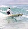
Looks like some waves are about if the cojones are big enough.

From www.stuff.co.nz

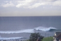
The MetService is warning heavy swells up to six metres high will hit the east coast of the North Island by Friday night.

The main area expected to be affected was between East Cape and Cape Palliser, with the ocean swells building to a high point by Friday night and easing from Saturday night.

MetService spokesman Bob McDavitt said the swell was being generated by former cyclone Gene.

This system had left the tropics and was moving southwards well to the east of New Zealand, Mr McDavitt said.

"We are forecasting that Saturday will be fine and warm with light winds or sea breezes, but anyone encouraged by the weather to go to the beach needs to be aware of the wild surf."

He said the sweep of some of the waves would come well inshore especially on the high tide near dawn and dusk.

As the easterly swell approached the beach it would break up into smaller, steeper rollers and help to form stronger rips than normal.

Mr McDavitt said that while the significant height of the swell - the average of the top third waves - was expected to be around four metres, the occasional wave, one in a hundred or so, was likely to be six metres.

User avatar
Hang11
SW Pro
 
Posts: 960
Likes: 0 post
Liked in: 0 post
Joined: Mon Apr 16, 2007 12:03 am
Location: smoko

Postby Hang11 » Thu Feb 07, 2008 10:13 pm

And next weekend :shock:

Image
User avatar
Hang11
SW Pro
 
Posts: 960
Likes: 0 post
Liked in: 0 post
Joined: Mon Apr 16, 2007 12:03 am
Location: smoko

Postby drowningbitbybit » Thu Feb 07, 2008 11:35 pm

Eeek! :shock:

Looking... er... big and scary.
That'll be one for some inland river surfing again :wink:

Can you post a link to those charts? ive not found many sites that show the synoptics on a global pacific scale. Ta!
User avatar
drowningbitbybit
Surfing Legend
 
Posts: 6459
Likes: 0 post
Liked in: 0 post
Joined: Tue Feb 15, 2005 11:16 am
Location: Gold Coast, QLD, Australia.

Postby Hang11 » Fri Feb 08, 2008 12:11 am

www.metvuw.com

http://www.marineweather.co.nz/index.php

They are NZ sites but they show what's going on over the ditch.

There's also swellmap.com - does a marine forecast for free, but most you have to pay for. The google earth overlay they do is really cool.

And buoyweather.com

http://www.buoyweather.com/wxnav6.jsp?r ... ogram=Maps

I reckon if that low hits the SI of NZ next weekend as forecast, the whole island might disappear. That's a massive storm.

Anyway, I'm looking for somewhere sheltered tomorrow. Mangamaunu will be epic on those conditions, but there's no way I've got the guts to paddle out in a swell like that.
User avatar
Hang11
SW Pro
 
Posts: 960
Likes: 0 post
Liked in: 0 post
Joined: Mon Apr 16, 2007 12:03 am
Location: smoko

Postby drowningbitbybit » Fri Feb 08, 2008 12:36 am

Thank's for the links - no wonder I couldnt find 'em, they're all hidden in NZ internet!

Hang11 wrote:I reckon if that low hits the SI of NZ next weekend as forecast, the whole island might disappear. That's a massive storm.


:shock: :lol: :shock: :lol:

Yeah, that looks like a 'sit on the balcony, drinking a beer, watching the tow-in teams' type of storm.
User avatar
drowningbitbybit
Surfing Legend
 
Posts: 6459
Likes: 0 post
Liked in: 0 post
Joined: Tue Feb 15, 2005 11:16 am
Location: Gold Coast, QLD, Australia.

Postby RJD » Fri Feb 08, 2008 12:43 am

Uh not my balcony. Not with that on the way...
RJD
SW Pro
 
Posts: 1373
Likes: 0 post
Liked in: 0 post
Joined: Mon Dec 05, 2005 7:37 pm
Location: Christchurch, New Zealand

Postby Hang11 » Fri Feb 08, 2008 1:01 am

You might end up with a million sheep shagger blow-ins on the Sydney beaches if it does happen.
User avatar
Hang11
SW Pro
 
Posts: 960
Likes: 0 post
Liked in: 0 post
Joined: Mon Apr 16, 2007 12:03 am
Location: smoko

Postby RJD » Fri Feb 08, 2008 1:30 am

Those red bits are off the chart 20mm+ in 6 hr rainfall.
RJD
SW Pro
 
Posts: 1373
Likes: 0 post
Liked in: 0 post
Joined: Mon Dec 05, 2005 7:37 pm
Location: Christchurch, New Zealand

Postby Hang11 » Fri Feb 08, 2008 1:41 am

A bit rain won't hurt, might even turn the brown back into green.

I'm loving the fetch of the wind at the bottom of the low, pointed right at us 8) That could be a really good swell coming in. Hopefully coupled with some nice offshore winds.

That really is a big low. Maybe the guy who drew the chart at the metservice just got this year's crop out the garden, and was off his face when he did it??
User avatar
Hang11
SW Pro
 
Posts: 960
Likes: 0 post
Liked in: 0 post
Joined: Mon Apr 16, 2007 12:03 am
Location: smoko

Postby Hang11 » Sat Feb 09, 2008 9:46 pm

I'm sitting in my kitchen watching some huge sets winding off down the beach, lined up for miles out to sea.

No way I'm paddling out in that. Pretty impressive to watch though.
User avatar
Hang11
SW Pro
 
Posts: 960
Likes: 0 post
Liked in: 0 post
Joined: Mon Apr 16, 2007 12:03 am
Location: smoko

Postby Sillysausage » Sat Feb 09, 2008 10:05 pm

go and get some piccies in
Sillysausage
SW Pro
 
Posts: 1185
Likes: 0 post
Liked in: 0 post
Joined: Thu Nov 16, 2006 6:56 pm
Location: East Coast, uk

Postby Tenaciousgreen » Sun Feb 10, 2008 2:32 pm

Can we have some of your swell here in WA please!

Its been flat as here on the. Perth Beachies
Tenaciousgreen
Grom
 
Posts: 44
Likes: 0 post
Liked in: 0 post
Joined: Sat May 05, 2007 1:51 pm
Location: Western Australia


Similar topics

Return to Surf Chat