
On Saturday evening, Roxy Ridgeback and billie went hunting for Chumash Indian paintings near the Fremont Trail. The trail is in the Santa Ynez Mountains and inside the Los Padres National Forest. The specific area they went to is located near the Chumash Painted Cave State Historic Park (http://www.parks.ca.gov/?page_id=602) and many "secret painting spots." They failed to find any paintings (this time).
The trail is named after John Charles Frémont (January 21, 1813 – July 13, 1890). He was an American military officer, explorer, and politician who became the first candidate of the anti-slavery Republican Party for the office of President of the United States (source Wikipedia). During the Mexican-American War, Fremont crossed the mountains on the trail bearing his namesake. This mission occurred at night during a torrential rainstorm on Christmas Eve 1846. At that time the trail was only a rough path. Frémont's lost 10 men, 150 horses and mules, and one cannon. The battalion was exhausted when they reached the Goleta Valley foothills by the next morning, They camped there for two days before claiming Santa Barbara from Mexico for the United States on 27 December 1846. .
Los Padres Nat'l Forest - Fremont Trail
6 posts
• Page 1 of 1
-
billie_morini - Surf God
- Posts: 3467
- Likes: 0 post
- Liked in: 0 post
- Joined: Mon Nov 19, 2007 2:07 am
- Location: Santa Barbara
Re: Los Padres Nat'l Forest - Fremont Trail
![]() by billie_morini » Sun Apr 07, 2019 9:02 pm
by billie_morini » Sun Apr 07, 2019 9:02 pm
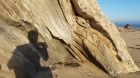
Sandstone with orange maritime sunburst lichen (Xanthoria parietina) Roxy, down below, accompanied me during most of the bouldering and rock hopping while looking for paintings. She's one of the most athletic dogs I've ever encountered. It's one of the primary reasons we've had so many amazing adventures together.
- Attachments
-
-
-
billie_morini - Surf God
- Posts: 3467
- Likes: 0 post
- Liked in: 0 post
- Joined: Mon Nov 19, 2007 2:07 am
- Location: Santa Barbara
Re: Los Padres Nat'l Forest - Fremont Trail
![]() by billie_morini » Sun Apr 07, 2019 9:04 pm
by billie_morini » Sun Apr 07, 2019 9:04 pm
We discovered this tremendous and distinguished oak growing against a sandstone outcrop.
- Attachments
-
-
-
-
billie_morini - Surf God
- Posts: 3467
- Likes: 0 post
- Liked in: 0 post
- Joined: Mon Nov 19, 2007 2:07 am
- Location: Santa Barbara
Re: Los Padres Nat'l Forest - Fremont Trail
![]() by billie_morini » Sun Apr 07, 2019 9:06 pm
by billie_morini » Sun Apr 07, 2019 9:06 pm
No ancient paintings, but many beautiful wildflowers this Spring!
- Attachments
-
-
-
billie_morini - Surf God
- Posts: 3467
- Likes: 0 post
- Liked in: 0 post
- Joined: Mon Nov 19, 2007 2:07 am
- Location: Santa Barbara
Re: Los Padres Nat'l Forest - Fremont Trail
![]() by billie_morini » Sun Apr 07, 2019 9:07 pm
by billie_morini » Sun Apr 07, 2019 9:07 pm
two more... The yellow one is one of my favorite mallows.
- Attachments
-
-
-
billie_morini - Surf God
- Posts: 3467
- Likes: 0 post
- Liked in: 0 post
- Joined: Mon Nov 19, 2007 2:07 am
- Location: Santa Barbara
Re: Los Padres Nat'l Forest - Fremont Trail
![]() by billie_morini » Sun Apr 07, 2019 9:25 pm
by billie_morini » Sun Apr 07, 2019 9:25 pm
We were out past dark. This is not too unusual for us and we sometimes venture into these nearby mountains between 20:00 and 24:00. We've seen hundreds of shooting stars, dozens of California Pink Glow Worms, hundreds of Whip-poor-wills and Woodcocks (Nighthawks), and one Coatimundi. You must remain alert because there are mountain lions and bears out there. Of the two, it's the mountain lions that concern me. Just yesterday, one was sighted deep within town between 04:00 and 05:00. If Roxy were not so large and strong, I probably wouldn't go out at night like this.
That's Lake Cachuma on the right. It's Santa Barbara's primary drinking water reservoir, It receives water from the Santa Ynez River and was built by the U.S. Bureau of Reclamation in 1953, The name "Cachuma" comes from a once nearby Chumash village that the early Spanish referred to as "Aquitsumu." The dam is an earth-fill structure having a height of about 200 feet (60 meters). When filled, the surface area covers 3,100 acres (1,300 ha) and maximum design capacity is 205,000 acre⋅ft (253,000,000 m3), As of the end of March 2019, it was filled to nearly 80% capacity! This is phenomenal because it was down to 15% to 20% last year following nine years of Extreme drought (note: that's even worse than severe drought).
That's Lake Cachuma on the right. It's Santa Barbara's primary drinking water reservoir, It receives water from the Santa Ynez River and was built by the U.S. Bureau of Reclamation in 1953, The name "Cachuma" comes from a once nearby Chumash village that the early Spanish referred to as "Aquitsumu." The dam is an earth-fill structure having a height of about 200 feet (60 meters). When filled, the surface area covers 3,100 acres (1,300 ha) and maximum design capacity is 205,000 acre⋅ft (253,000,000 m3), As of the end of March 2019, it was filled to nearly 80% capacity! This is phenomenal because it was down to 15% to 20% last year following nine years of Extreme drought (note: that's even worse than severe drought).
- Attachments
-
-
billie_morini - Surf God
- Posts: 3467
- Likes: 0 post
- Liked in: 0 post
- Joined: Mon Nov 19, 2007 2:07 am
- Location: Santa Barbara
6 posts
• Page 1 of 1
Similar topics
Los Padres Nat'l Forest - Santa Ynez River & Snyder Trail
RELATED: Photos and Surf Photography
Author: billie_morini
Replies: 9
RELATED: Photos and Surf Photography
Author: billie_morini
Replies: 9
Los Padres Nat'l Forest - Figueroa Mountain
RELATED: Photos and Surf Photography
Author: billie_morini
Replies: 9
RELATED: Photos and Surf Photography
Author: billie_morini
Replies: 9
Shop

Latest
-
3 minutes ago by Kulharin2 comments
-
9 days ago by Swimmy Tim5 comments
-
10 days ago by BaNZ3 comments
-
16 days ago by BoMan6 comments
-
19 days ago by hannaconner5 comments
-
1 month ago by BaNZ4 comments
-
1 month ago by HaoleKook4 comments
-
1 month ago by Jimgem2 comments